- Use cases
- Co-Creation Space
Community
Organizations
Collaboration Partners

- Login
NOT REGISTERED YET?
Register for the Use Case Management Service for free to start creating your first use case.
Registered users can use the download area and the comment functions.

All dokuments are licensed as a Creative Commons Attribution-NonCommercial-ShareAlike 4.0 International License
(Attribution-Non-Commercial-ShareAlike 4.0). Further information can be found at
![]()
The documents reflect the current best practice and do not claim to be complete. They should not to be understood in the sense of a generally valid recommendation or guideline from a legal point of view. The documents are intended to support appointing and appointed parties in the application of the BIM method. The documents must be adapted to the specific project requirements in each case. The examples listed do not claim to be complete. Its information is based on findings from practical experience and is accordingly to be understood as best practice and not universally applicable. Since we are in a phase in which definitions are only emerging, the publisher cannot guarantee the correctness of individual contents.
This document aims at describing ‘Historical Weather Data Collection’ use case which is implemented as part of BIM-SPEED EU Horizon2020 project.
Aim: The ‘Mereen weather service’ was developed to:
Scope: the main benefit of this service is during calibration of building energy models with energy bills. Accurate building energy models are required for understanding the as-is situation of the building, so that renovation alternatives are operational.
In line with the aim of BIM-Speed project, Mereen weather service helps in:
In renovation projects, a good understanding of the as-is situation of the building is required to develop realistic alternatives for renovation. The as-is situation of the building includes not only collecting relevant data for the building but also exterior situation including historical weather data. The as-is building energy models are required to be calibrated with previous years energy bills. Therefore, the real weather data for those specific years is a pre-requisite. Mereen weather service implemented as part of BIM-Speed projects help collecting such datasets. The main use case of developing this service is calibrating building energy models of the building.
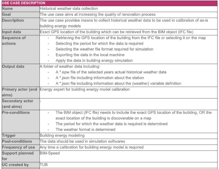
One of the main objectives of the BIM-SPEED project is to reduce the time of deep renovation projects by 30%.
On the other hand, increasing the accuracy of the building renovation is another objective of this project. The Mereen weather service helps reducing the time required for collecting historical data dramatically by only some clicks. The retrieved data helps in increasing the accuracy of building energy models via calibration procedure as well.
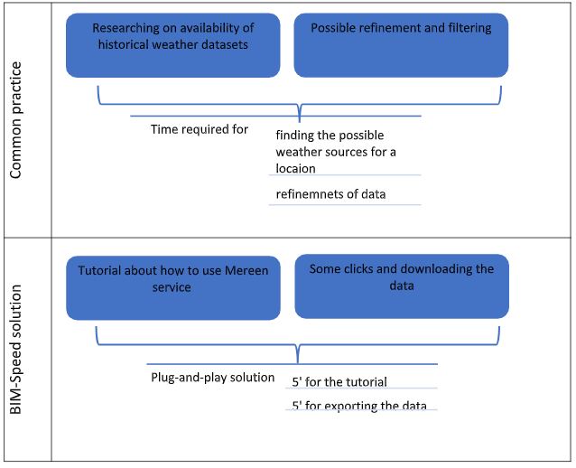
Figure 1: Common practice versus BIM-Speed approach for historical weather data collection
Mereen service is a REST API which retrieves data from IFC file. The ifcSite component of the IFC file needs to include the GPS location of the building. With this information the retrieved information is the location of the nearest weather station. In the next stage, this information is used along with two inputs from the user, and the retrieved data are weather data in EPW format and some json files with information about variable and stations.
Figure 12: Exchange requirement in Mereen weather service
The overall process starts with selection of the exact location of the building from the IFC file or manually on a map. Then the period for which the weather data is required should be selected by the user as well as the required weather data format. The result after selecting export will be a zip file reachable in the BIM-Speed platform. The zip file can be downloaded in a local machine. It includes EPW file the selected period, json files with information about the weather station and weather parameters.
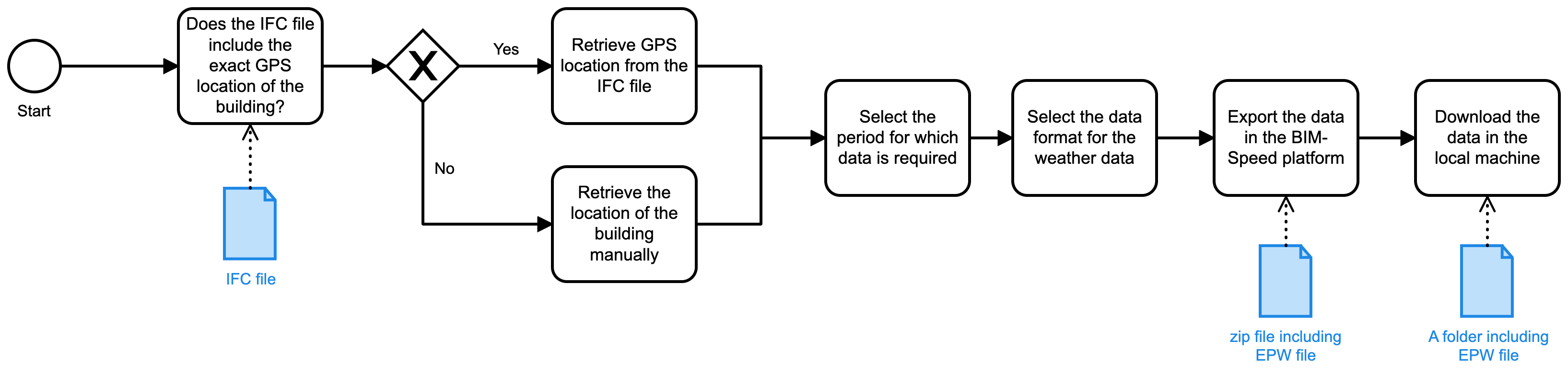
Figure 2: Process map of historical weather data collection use case
The Mereen weather service is integrated into BIM-Speed platform and accessible from there.
The first step to implementing this tool in this procedure is selection of the exact location of the building under renovation on the Earth. This can be extracted from the ifcSite component of the IFC file. Figure below shows how to access this service from the BIM-Speed platform.
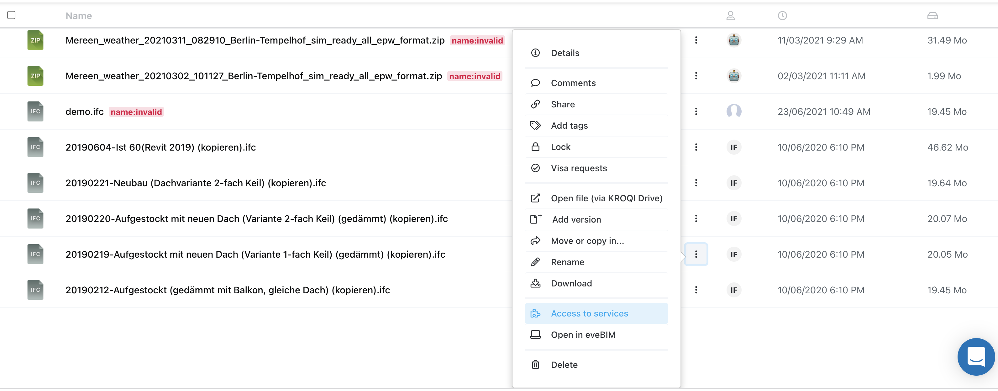 Figure 3 : Access to the Mereen weather service via the BIM-SPEED platform
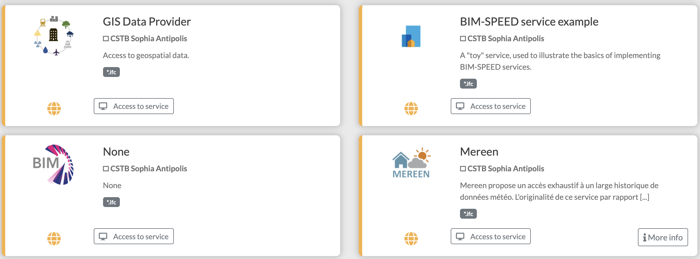
Figure 4 : List of available services on the BIM-SPEED platform
Clicking on the ‘Go to the service’ opens a wizard which shows information about the retrieved nearest weather station. It includes information about the sources from which data is collected, their validity and starting and ending date of the data availability. The wizard also includes two sections for the user to select the period and data format of the desired data (Figures below).
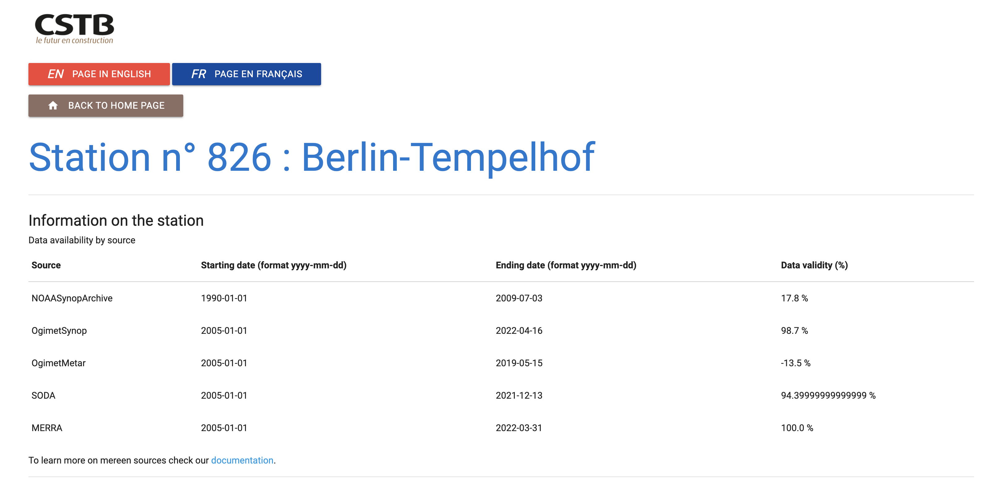
Figure 5: Information about the nearest weather station to the building

Figure 6: Selection of period of interest in Mereen weather service
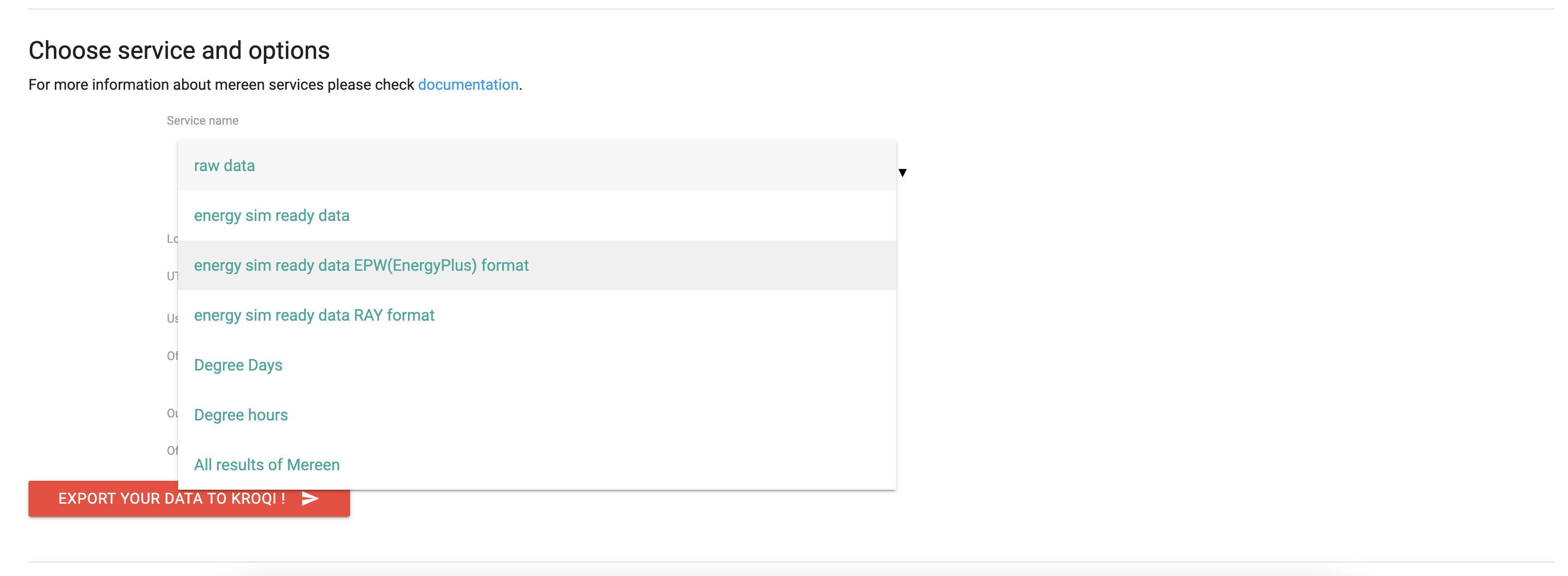
Figure 7: Selection of weather format in Mereen weather service
By clicking on ‘Export’, a zip file will be downloaded in the same folder as the ifc file. The zip file includes epw file/files of the desired year/years. It also includes some json files including information about variable definition and station information.
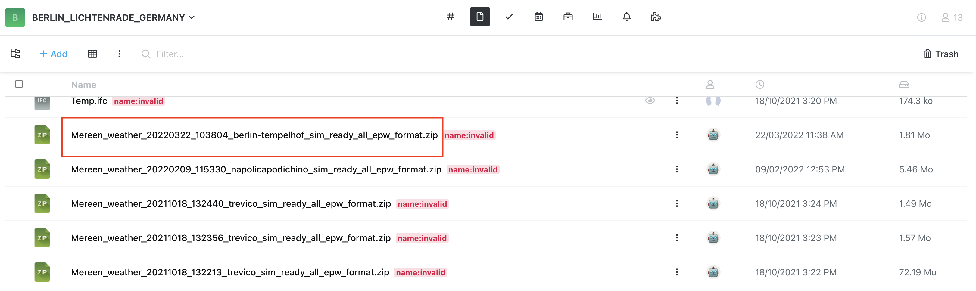
Figure 8: Downloading the weather data (zip file) on BIM-SPEED platform
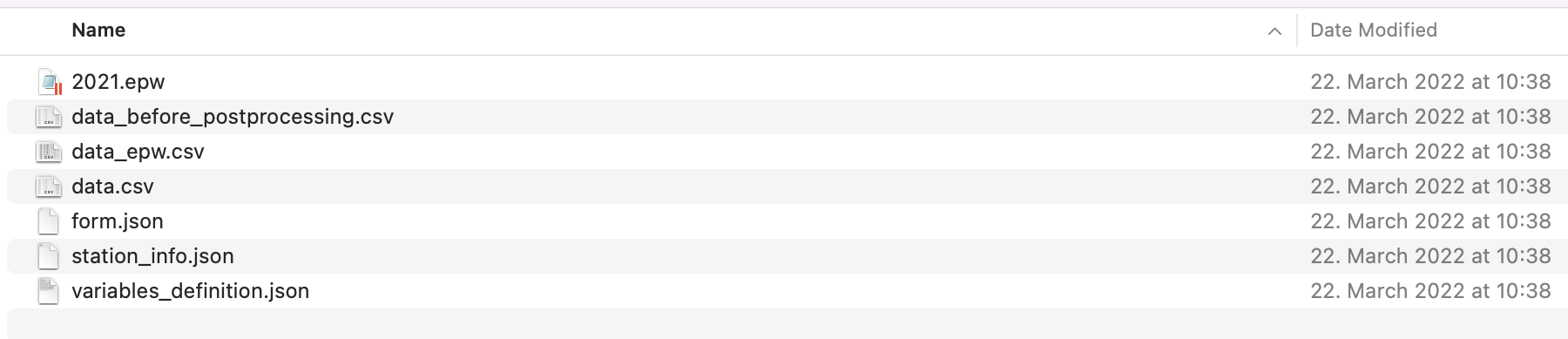
Figure 9:Content of the zip file after downloading on a local machine
There are some requirements for collecting the weather data through Mereen service. Firstly, the exact GPS location of the building is required. This information can be either integrated into the BIM object (ifc file) or selected on a map. This step is reflected on the process map as shown in figure below.
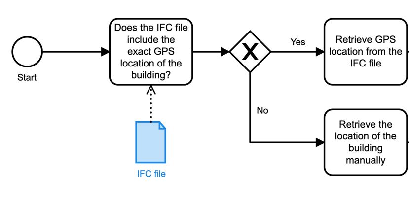
Figure 10: Extraction of location of building
Then the period and data format are required which should be selected by the user. This step is reflected on the process map as below.
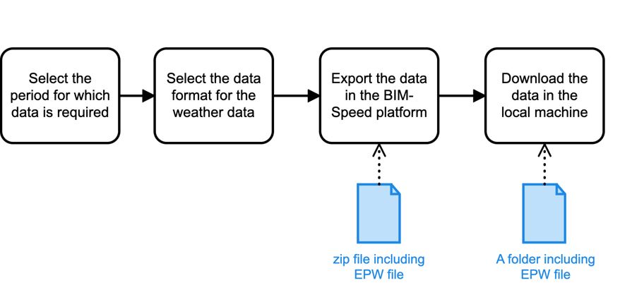
Figure 11: Selection of period and weather data format
As a pre-requisite for the extraction of best weather data for a location, the following are required:
In comparison to the conventional approach for collecting the required datasets, the benefit of using the tool can be seen in:
For any location of interest, it is possible that all required data for all years are not available. The reason is that the data is collected from different sources, and the result is dependent on the availability on those sources.